Advanced Air Mobility State-of-Practice Review
An independent study report synthesizing Advanced Air Mobility developments across aircraft typologies, certification frameworks, vertiport infrastructure, FAA/NASA initiatives, market readiness, and governance challenges. The project reviewed eVTOL, eSTOL, lift-plus-cruise, and hybrid fly-drive systems to assess how AAM may evolve from demonstration flights toward scalable mobility services.
Project Details
Overview
An independent study report synthesizing the current state of Advanced Air Mobility (AAM). The review covers aircraft typologies, certification frameworks, vertiport infrastructure, FAA and NASA initiatives, market readiness, and governance challenges, with the goal of assessing how AAM may evolve from demonstration flights toward scalable urban and regional mobility services.
Tools Used
State-of-Practice Literature Review · FAA & EASA Regulatory Synthesis · NASA AAM National Campaign Review · Vertiport Design Standards Review · Aircraft-Typology Comparison · Market & Governance Analysis
My Role
Authored the independent study end-to-end: scoping the review, synthesizing regulatory and technical sources, comparing aircraft typologies, mapping vertiport and infrastructure considerations, and developing the deployment-pathway analysis.
Method
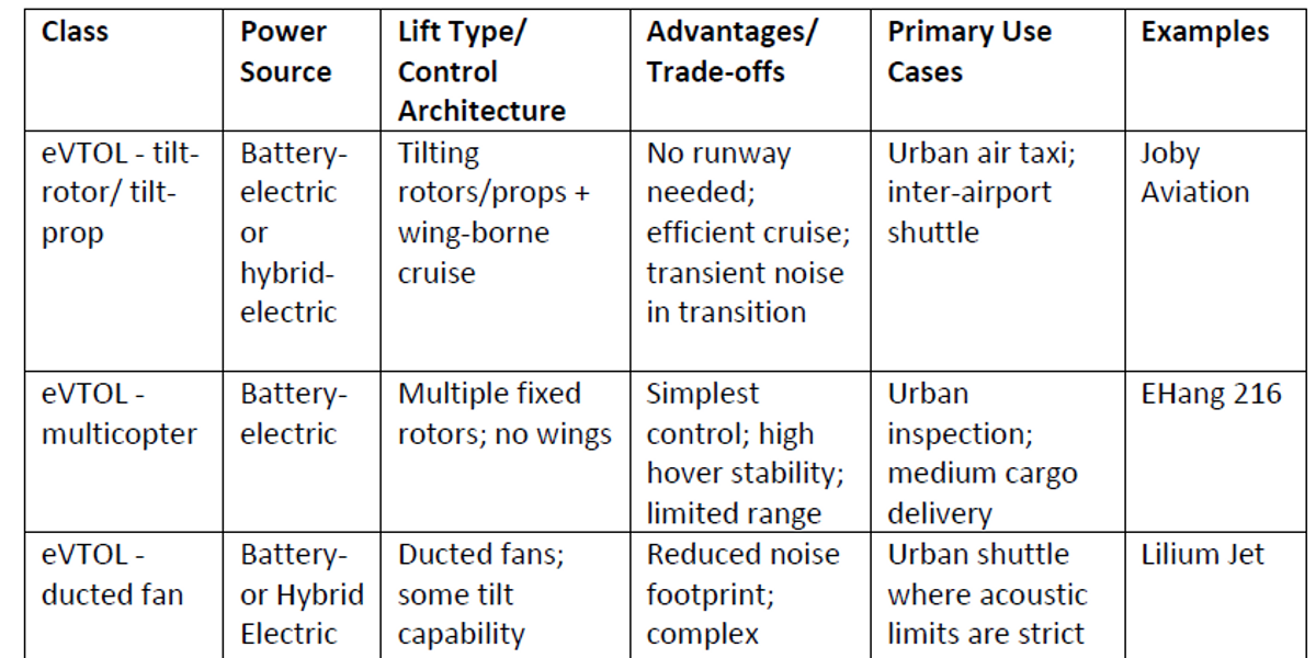
The report synthesized published technical, regulatory, and program documentation across the AAM ecosystem. Aircraft were grouped into eVTOL, eSTOL, lift-plus-cruise, and hybrid fly-drive typologies, and compared on payload, range, takeoff/landing requirements, and infrastructure implications. Certification was reviewed across FAA and EASA frameworks, including the FAA's Innovate28 effort and NASA's AAM National Campaign. Vertiport considerations covered siting, charging, fire/life-safety, and airspace integration. Market readiness and governance were examined together — bringing capital, operations, and regulation into a single deployment view.
Key Outcomes
- Mapped AAM aircraft typologies — eVTOL, eSTOL, lift-plus-cruise, and hybrid fly-drive — against payload, range, and infrastructure profiles.
- Synthesized FAA and EASA certification pathways and the FAA Innovate28 plan into a single regulatory view.
- Reviewed NASA's AAM National Campaign as the bridge between demonstration flights and operational service.
- Pulled vertiport siting, charging, and airspace integration into a coherent infrastructure picture.
- Identified governance gaps and market-readiness constraints that bound near-term deployment pathways toward urban air taxi and regional mobility services.
Limitations
The report is a state-of-practice synthesis rather than original simulation or field study. Many AAM developments are moving quickly, so specific certification statuses, vertiport standards, and market positions reflect the review window and may shift. Cost estimates and deployment timelines from industry sources vary widely and were treated as ranges rather than predictions.
Related Projects
John Nolen Drive Traffic Flow Improvement
Traffic Control / VISSIM Simulation
A graduate traffic-control project using PTV VISSIM, HCS, and Excel to evaluate 2035 traffic growth and improvement strategies along John Nolen Drive in Madison. I led the analysis and quality control, comparing no-build, signal-optimized, and geometry-refined scenarios. Results showed 2035 growth could increase delay by 60–85% and queues by 3×, while signal and geometry improvements provided targeted but capacity-limited benefits.
Open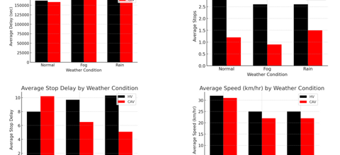
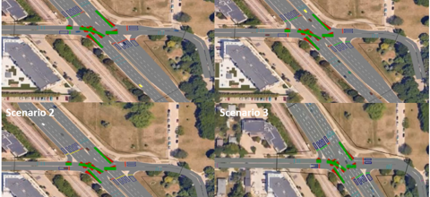
Connected and Automated Vehicles in Adverse Weather
Advanced Traffic Modeling / CAVs
A VISSIM-based advanced traffic modeling project evaluating how Connected and Automated Vehicles may improve traffic performance under normal, fog, and rain conditions along Madison's Beltline corridor. The study compared human-driven vehicles and CAVs using weather-based speed reductions, Wiedemann 99 car-following parameters, lane-changing behavior, and performance metrics such as delay, stops, stop delay, and speed.
Open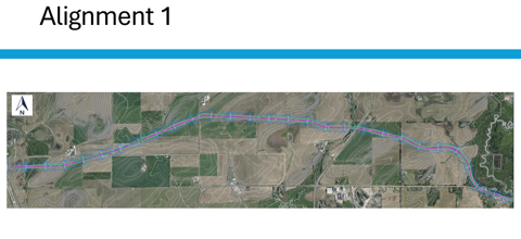
North Mendota Parkway Design
Highway Design / Civil Infrastructure
A graduate highway-design project developing a conceptual 4.75-mile North Mendota Parkway corridor in Dane County. The work evaluated alternative alignments, farmland/hydrologic/terrain constraints, vertical and horizontal geometry, AASHTO Green Book design standards, traffic forecasting, and six intersection concepts to support a rural principal arterial design.
Open