John Nolen Drive Traffic Flow Improvement
A graduate traffic-control project using PTV VISSIM, HCS, and Excel to evaluate 2035 traffic growth and improvement strategies along John Nolen Drive in Madison. I led the analysis and quality control, comparing no-build, signal-optimized, and geometry-refined scenarios. Results showed 2035 growth could increase delay by 60–85% and queues by 3×, while signal and geometry improvements provided targeted but capacity-limited benefits.
Project Details
Overview
CIV ENGR 574 – Traffic Control | University of Wisconsin–Madison. Submitted to Professor Xiaopeng Li, Ph.D., P.E.
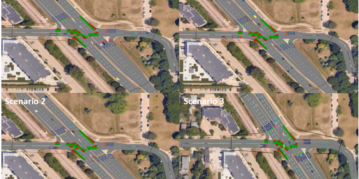
This graduate traffic-control project evaluated how projected 2035 traffic demand could affect operations along John Nolen Drive, a major Madison corridor, and tested whether signal timing and geometry-based improvements could reduce future congestion. The study focused on three intersections: John Nolen Drive & North Shore Drive, John Nolen Drive & Lakeside Street, and John Nolen Drive & Olin Avenue.
The project compared a 2023 base model, a 2035 no-build scenario, signal timing optimization, and targeted geometric refinements such as connector smoothing and turn-lane storage improvements.
Tools Used
PTV VISSIM · HCS · Excel · Traffic Growth Forecasting · Signal Timing Optimization · Scenario Comparison · MOE Evaluation
My Role
I took primary responsibility for the project's technical quality and on-time delivery, including modeling supervision, traffic-growth calculations, scenario comparison, output verification, result interpretation, quality control, and final presentation refinement.
Method
The model used Wiedemann-74 car-following behavior, 2-hour simulation periods with warm-up time, and repeated runs to stabilize stochastic outputs. Measures of effectiveness included delay, speed, travel time, stops, queue length, and level of service. Scenario development moved sequentially from a calibrated 2023 base, to a 2035 no-build case using projected growth factors, to signal-timing optimization, and finally to targeted geometric refinements. Result interpretation focused on prioritizing high-volume movements — saving 1 second on a movement serving 2,000 vehicles can be more valuable than saving 3 seconds on a movement serving 100 vehicles.
Key Outcomes
- Modeled three connected John Nolen Drive intersections under existing and projected future demand.
- Compared base, 2035 no-build, signal-optimized, and geometry-refined scenarios.
- Found that 2035 growth caused the largest degradation, with 60–85% higher delay and approximately 3× queue lengths.
- Found that signal optimization improved delays by 10–12%, but did not fully resolve capacity pressure.
- Found that geometry refinements improved Intersections 1 and 3 and reduced stops, improving traffic smoothness.
- Applied practical traffic-engineering judgment by prioritizing high-volume movements for greater systemwide impact.
Limitations
Signal timing optimization reduced delay but queues remained constrained because projected arrivals still approached or exceeded capacity. Geometry changes worsened Intersection 2 slightly compared with the signal-optimized scenario, likely due to mid-corridor pressure where upstream improvements concentrated demand on a movement that could not be physically widened. Outcomes are bounded by the demand forecasts, the calibration of the 2023 base model, and the limited set of geometry levers tested at the corridor scale.
Related Projects
Connected and Automated Vehicles in Adverse Weather
Advanced Traffic Modeling / CAVs
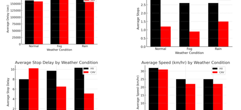
A VISSIM-based advanced traffic modeling project evaluating how Connected and Automated Vehicles may improve traffic performance under normal, fog, and rain conditions along Madison's Beltline corridor. The study compared human-driven vehicles and CAVs using weather-based speed reductions, Wiedemann 99 car-following parameters, lane-changing behavior, and performance metrics such as delay, stops, stop delay, and speed.
Open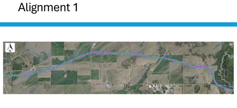
North Mendota Parkway Design
Highway Design / Civil Infrastructure
A graduate highway-design project developing a conceptual 4.75-mile North Mendota Parkway corridor in Dane County. The work evaluated alternative alignments, farmland/hydrologic/terrain constraints, vertical and horizontal geometry, AASHTO Green Book design standards, traffic forecasting, and six intersection concepts to support a rural principal arterial design.
Open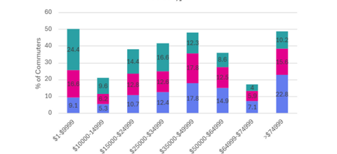
Fair Fares or Financial Burdens?
Urban Transportation Planning / Transit Equity
A graduate urban transportation planning project reviewing transit fare policy through equity, affordability, and financial-sustainability lenses. The study examined how fare structures can burden low-income, zero-car, and suburban riders, and evaluated tools such as fare capping, means-based discounts, fare-free pilots, and account-based fare systems using Madison as a local application case.
Open