Fair Fares or Financial Burdens?
A graduate urban transportation planning project reviewing transit fare policy through equity, affordability, and financial-sustainability lenses. The study examined how fare structures can burden low-income, zero-car, and suburban riders, and evaluated tools such as fare capping, means-based discounts, fare-free pilots, and account-based fare systems using Madison as a local application case.
Project Details
Overview
A graduate urban transportation planning project reviewing public transit fare policy through equity, affordability, and financial-sustainability lenses. The study examined how different fare structures can disproportionately burden low-income riders, zero-car households, and suburban commuters, and tested how modern policy and technology tools can soften that burden while preserving the financial sustainability of transit agencies. Madison was used as a local application case to ground the policy discussion in a specific service context.
Tools Used
Policy Review · Equity Frameworks (Vertical / Horizontal / Spatial) · Comparative Fare-Structure Analysis · Account-Based Fare Systems · Fare Capping · Means-Based Discount Programs · Fare-Free Pilot Review · Madison Application Case
My Role
Authored the review end-to-end: scoping the equity framing, surveying fare-structure types, comparing peer-agency programs, evaluating tool effectiveness, and applying the findings to the Madison context.
Method
The paper synthesized literature and peer-agency practice on fare structures (flat, distance-based, zone-based, time-based, mode-based, and group-based) and evaluated each through three equity lenses: vertical (ability to pay), horizontal (similar treatment for similar trips), and spatial (geographic fairness across urban and suburban riders). Mitigating tools — fare capping, means-based discount programs, fare-free pilots, and account-based fare systems — were assessed for who they actually reach, what they cost agencies, and how they interact with sustainability constraints. Madison's transit context was used as a local application case to make the comparisons concrete.
Key Outcomes
- Mapped how flat, distance-based, zone-based, time-based, mode-based, and group-based fare structures shift cost burden across rider populations.
- Showed that low-income, zero-car, and suburban riders are most exposed under conventional fare structures, with spatial equity often the weakest dimension.
- Evaluated fare capping and account-based fare systems as practical near-term tools that deliver discounts without requiring riders to pre-qualify for passes.
- Reviewed means-based discount and fare-free pilot programs, noting strong access gains balanced against revenue and political-sustainability tradeoffs.
- Applied findings to Madison as a local case to illustrate where each policy tool would have the most impact.
Limitations
The review is policy-level rather than a quantitative ridership or revenue model — agency-specific impacts depend on demand elasticities, demographic mix, and operating cost structure that were outside the scope. Data on means-based and fare-free programs is uneven across agencies, so cross-agency comparisons rely on reported outcomes that vary in rigor. The Madison application case is illustrative rather than a full local feasibility study.
Related Projects
John Nolen Drive Traffic Flow Improvement
Traffic Control / VISSIM Simulation
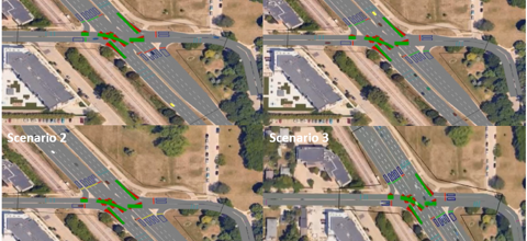
A graduate traffic-control project using PTV VISSIM, HCS, and Excel to evaluate 2035 traffic growth and improvement strategies along John Nolen Drive in Madison. I led the analysis and quality control, comparing no-build, signal-optimized, and geometry-refined scenarios. Results showed 2035 growth could increase delay by 60–85% and queues by 3×, while signal and geometry improvements provided targeted but capacity-limited benefits.
Open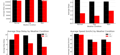
Connected and Automated Vehicles in Adverse Weather
Advanced Traffic Modeling / CAVs
A VISSIM-based advanced traffic modeling project evaluating how Connected and Automated Vehicles may improve traffic performance under normal, fog, and rain conditions along Madison's Beltline corridor. The study compared human-driven vehicles and CAVs using weather-based speed reductions, Wiedemann 99 car-following parameters, lane-changing behavior, and performance metrics such as delay, stops, stop delay, and speed.
Open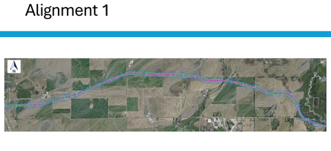
North Mendota Parkway Design
Highway Design / Civil Infrastructure
A graduate highway-design project developing a conceptual 4.75-mile North Mendota Parkway corridor in Dane County. The work evaluated alternative alignments, farmland/hydrologic/terrain constraints, vertical and horizontal geometry, AASHTO Green Book design standards, traffic forecasting, and six intersection concepts to support a rural principal arterial design.
Open