North Mendota Parkway Design
A graduate highway-design project developing a conceptual 4.75-mile North Mendota Parkway corridor in Dane County. The work evaluated alternative alignments, farmland/hydrologic/terrain constraints, vertical and horizontal geometry, AASHTO Green Book design standards, traffic forecasting, and six intersection concepts to support a rural principal arterial design.
Project Details
Overview
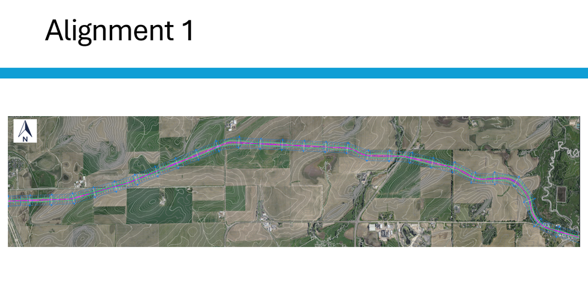
A graduate highway-design project developing a conceptual 4.75-mile North Mendota Parkway corridor in Dane County, Wisconsin, connecting USH 12 to CTH K and CTH M. The work moved from corridor-level alternatives through detailed horizontal and vertical alignment for a preferred route, applying AASHTO Green Book criteria for a rural principal arterial.
Tools Used
AASHTO Green Book Design Standards · Horizontal & Vertical Alignment Design · Traffic Forecasting · GIS Terrain & Hydrologic Review · Intersection Concept Development · CAD Layout
My Role
Led the corridor-design study end-to-end, including alternatives screening, alignment development for the preferred route, geometric design checks against AASHTO criteria, traffic forecast translation into design volumes, and intersection-concept development.
Method
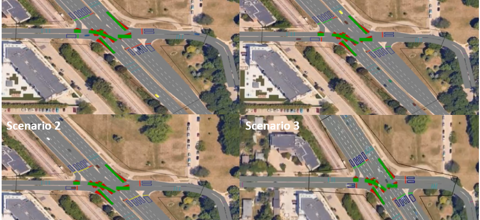
The study began with a screening of alternative alignments across the 4.75-mile corridor against farmland preservation, hydrologic features, and terrain constraints. A preferred alignment was advanced into detailed horizontal and vertical design — curve radii, superelevation, stopping sight distance, vertical curve K-values, and grade limits — referenced to AASHTO Green Book standards for a rural principal arterial. Traffic forecasts were translated into design-hour volumes and turning movements at the corridor's six intersection locations, where a range of concept treatments (at-grade signalized, two-way stop, and roundabout configurations) were sketched and compared on operational, safety, and right-of-way grounds.
Key Outcomes
- Produced a conceptual 4.75-mile rural principal arterial alignment connecting USH 12 to CTH K and CTH M.
- Evaluated alternative alignments against farmland, hydrologic, and terrain constraints to select a preferred route.
- Designed horizontal and vertical geometry that satisfies AASHTO Green Book criteria for the corridor's design speed.
- Translated traffic forecasts into design-hour volumes used to size lanes and intersection concepts.
- Developed six intersection concepts spanning at-grade signalized, stop-controlled, and roundabout treatments.
Limitations
The design is at a conceptual planning level — no final right-of-way, drainage, or pavement structural design was completed. Environmental and stakeholder review was scoped to terrain, hydrology, and farmland indicators rather than a full NEPA-style evaluation. Intersection concepts were screened operationally but not micro-simulated, and construction cost was not estimated.
Related Projects
John Nolen Drive Traffic Flow Improvement
Traffic Control / VISSIM Simulation
A graduate traffic-control project using PTV VISSIM, HCS, and Excel to evaluate 2035 traffic growth and improvement strategies along John Nolen Drive in Madison. I led the analysis and quality control, comparing no-build, signal-optimized, and geometry-refined scenarios. Results showed 2035 growth could increase delay by 60–85% and queues by 3×, while signal and geometry improvements provided targeted but capacity-limited benefits.
Open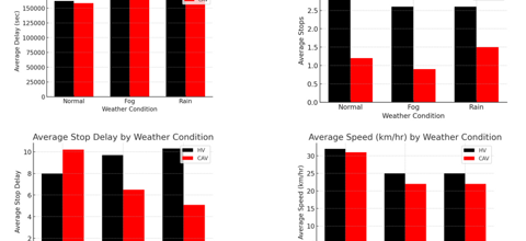
Connected and Automated Vehicles in Adverse Weather
Advanced Traffic Modeling / CAVs
A VISSIM-based advanced traffic modeling project evaluating how Connected and Automated Vehicles may improve traffic performance under normal, fog, and rain conditions along Madison's Beltline corridor. The study compared human-driven vehicles and CAVs using weather-based speed reductions, Wiedemann 99 car-following parameters, lane-changing behavior, and performance metrics such as delay, stops, stop delay, and speed.
Open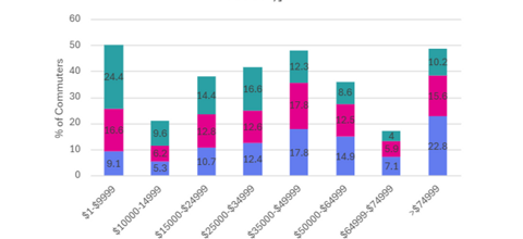
Fair Fares or Financial Burdens?
Urban Transportation Planning / Transit Equity
A graduate urban transportation planning project reviewing transit fare policy through equity, affordability, and financial-sustainability lenses. The study examined how fare structures can burden low-income, zero-car, and suburban riders, and evaluated tools such as fare capping, means-based discounts, fare-free pilots, and account-based fare systems using Madison as a local application case.
Open